|
Click to Download
|
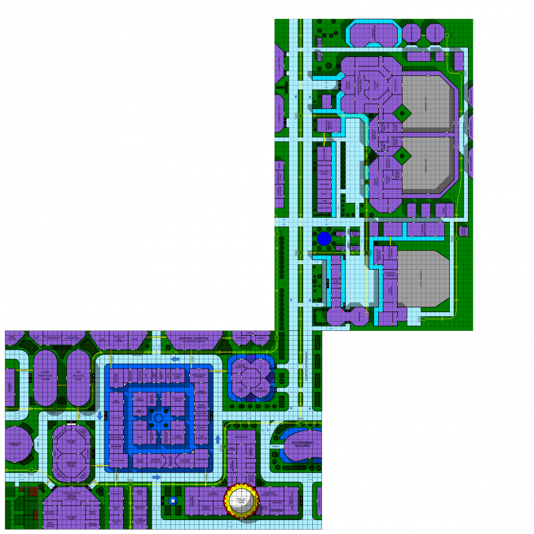
Port Loren Starport Map
|
 February 11, 2017 - 4:22pm | I really like this map and am working it into my SFAD Basic game for my kids. I did note one thing to switch if you ever update or add more to it: With both maps printed in taped together so that the monorail and expressway connect, the traffic flow arrows on Starport Expressway are reversed from the arrows on the Port Loren downtown map. Tom Stephens article on Mapping Port Loren http://www.arcanegamelore.com/mapping-port-loren/ also had some notes on shadow layers for the buildings and how the shadow layer maps to the walkways and monorails. |
 February 11, 2017 - 4:31pm | I'm actually looking to redo this one next. I'm working on the station deck plans from the KH map right now but once that's done, this is my next project. I'll be sure to fix that little bit. Ad Astra Per Ardua! My blog - Expanding Frontier Webmaster - The Star Frontiers Network & this site Founding Editor - The Frontier Explorer Magazine Managing Editor - The Star Frontiersman Magazine |
February 11, 2017 - 9:36pm | I imagine the star port map to be some distance from the down town map. I expect that a starport needs a bit of space and is not safe to be so near to down town. Think of rockets blasting off from pads in the distance from this map and ships thrusting in to land verticle. Did you really intend for this map to connect directly to the down town map? -iggy |
 February 15, 2017 - 7:43pm | For me, the starport map is not the actual blast-off point. I saw Space Shuttle mission STS-77 lift off in person. I guarantee that there is no 30m tall monorail line running right by that pad and surviving that awesome fury.. For me, this map is the hub... much like an airport terminal where the planes themselves are further along. Once you make it to a terminal, you are shuttled out further away to the actual vehicle. Jetcopters and stuff could take off directly from the local terminal, and other specialized carriers from terminal one and terminal two go out to the actual spacecraft servicing areas and launchpads. For a real world analogue - take a look at the Kennedy Space Center design compared to where the rockets and shuttles lift off. Google maps can take you there and you can see the high-traffic KSC area compared to where the actual rocket pads are. That's how I picture the spaceport map extension compared to where the spacecraft actually are, much further north. It does mean some of the residential blocks around downtown have the same problems that residentials have in Titusville - namely needing plexi windows instead of glass on the side facing the launch towers... |
 February 15, 2017 - 9:44pm | A lot of good points Exile. However, shuttles with lifting bodies (horrizontal deckplans) could be towed up to the terminal and towed away much like an aircraft. I might not be a dralasite, vrusk or yazirian but I do play one in Star Frontiers! |
 February 17, 2017 - 4:06pm | Jedion yeah, I could see that. If you picture the Pan-Am spaceplane from 2001 A Space Odyssey ... the main passenger body could load up at the terminals, then taxi out to the launch pad where the rear booster is mated, and away it goes... lots of possibilities. Another thing, there are a lot of empty spaces on this map to "fill in" - most airports only have that many empty spaces if something is going really down hill. In my SF Universe, Port Loren is always buzzing, so those empty spaces would be taken up with offices for the Frontier corporations listed in the Knight Hawks campaign books, as well as local fronts for the Malthar, the Star Devil etc. |
February 18, 2017 - 6:32pm | Exile, Thanks for pointing out the Kennedy Space Center next to Titusville Florida. This is much like I view the Port Loren Starport. It is a little seperated from the city, then the actual lanuch and landing sites are further out. I imagine that they are accessed by underground transport tubes that take passangers and crew out to the less mobile ships that cannot taxi to a terminal. This is the kind of concept I was hoping to get across. -iggy |
 February 20, 2017 - 7:30am | As promised I gave this map a workover to make it match the style I used for the Port Loren map. I actually did three versions. The first is just a straight up re-creation with the arrows on the expressway fixed (and the map rotated) Refer to: Port Loren Starport - rework On the second I added shadows to the buildings assuming that the long edge was north just like in the Port Loren map For the final version I assumed the short edge was north so that you could put the maps right up next to each other if you wanted and did the shadows appropriately Use whichever you like. Ad Astra Per Ardua! My blog - Expanding Frontier Webmaster - The Star Frontiers Network & this site Founding Editor - The Frontier Explorer Magazine Managing Editor - The Star Frontiersman Magazine |
 February 26, 2017 - 1:39pm | @TerlObar I am really grooving on the recreated maps, but I've run into a hitch with the starport map - I hate to keep nitpicking, but when you align the expressway and monorail, the shadows for the downtown map are opposite of the shadows on the starport map. Here's a view of what I see when I hook them up with the local terminal closer to downtown, and the expressway and monorail joined (which you don't get if you put the other short edge against downtown):  |
 February 26, 2017 - 4:04pm | I was thinking people lined them up the other way. (I actually assume they don't connect but are separated by a bit of distance) The shadows are easy to do. I can whip up another version that has them the right way for this orientation. Ad Astra Per Ardua! My blog - Expanding Frontier Webmaster - The Star Frontiers Network & this site Founding Editor - The Frontier Explorer Magazine Managing Editor - The Star Frontiersman Magazine |
April 14, 2022 - 9:07am | Hey all! Original creator of this map here. Had no idea it was here. At least, I have no recollection of putting it here... Just a couple design comments I had when creating this: 1) My thoughts were that it was NOT adjacent to the Port Loren city map but it was some distance away. 2) This is a shuttle docking port. Not for full sized ships. An assualt scout might be the biggest thing this sort of port could handle. 3) The arrows pointing the wrong way... yeah, that was totally unintentional. Not sure how I missed that... That said, I also did design it with the intention of it being lined up with the existing Port Loren map for convienence. So glad to see people enjoy this work!! "You don't know the Power of the Dark Side. I must obey my Master." |